Wednesday, February 25, 2009

The wild west coast of Lewis.


On the morning of the 5th of June 2008, the MV Cuma steamed out of the shelter of Loch Roag for the last time on our trip.


We passed inside of beautiful Eilean Mhealasta...


...and below the dark rocks of Aird Mor Mangurstadh.


We were glad we were not rounding Gallan Head in kayaks, given these conditions.


MV Cuma then nosed into Loch Roag and passed the great arch of Eala Sheadha...


...before Murdani dropped her anchor, a little distance off Bhaltos pier.


Cuma had covered 39km of some of the finest paddling coastline anywhere. I would love to return and paddle it but such an expedition would require much calmer conditions than those we had just encountered.

05/06/2009

Tuesday, February 24, 2009

Any port in a storm.


We rounded Portachur Point on the SW of Great Cumbrae and found some very satisfying conditions. We were looking forward to a blast up the far side of the island.


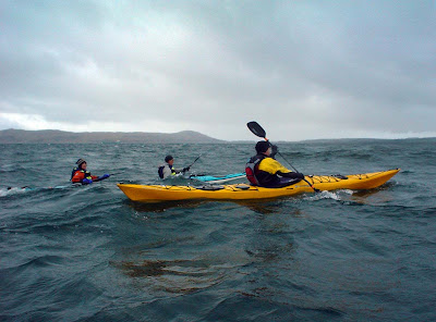
Unfortunately Alan's skeg had now jammed down and he was having real problems with leecocking. The swell began to pick up and even HMS Dreadnought was now hull down. I caught a wave and got up to 15km/hr, unfortunately Alan got caught by the same wave and went for a little swim.


He was soon back in his boat and enjoying himself again, despite the chill conditions, thanks to his dry suit. We got his skeg up and he learned to make progress downwind without it. We then made rapid progress up the far side of Cumbrae with following wind and swell.


Rounding a point we found Fintray Bay to be almost sheltered, so we stopped...


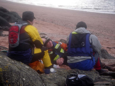
....for a second luncheon.


The staff at seakayakphoto.com have simple tastes. For our little picnic, on the ruby sands of Cumbrae, we enjoyed a rich Stilton cheese with oatcakes and washed it down with a bottle of Cockburn's Special Reserve port. In truth, this was not just any port in a storm, it is truly the finest of ports!


Heading back to Fairlie, on the lee side of Cumbrae, the fresh wind caused carnage amongst fleets of Laser, Laser Radial and Optimist dinghies from the National Sailing Centre. Their attendant RIBs were busy with the frequent capsizes. Unfortunately Alan was troubled by weathercocking, as his skeg had now jammed up. I tried to get my finger round the end of it but in the absence of a little loop of line at its tip, I couldn't get enough leverage. Alan was tiring fast so I put a line on his bow and gave him an assisted tow to keep his bow pointing to Fairlie.

An excellent day out with good company, fine food and drink and some good lessons learned as well!

Health Warning: alcohol and sea water do not mix!

21/02/2009

Monday, February 23, 2009

Sea kayaking to Great Cumbrae.


The coastal forecast for the Clyde on Saturday past was "Wind speed F4-5 Wind direction - SW Max gust in knots - 27". It was perfect for a little jaunt from Fairlie over to the Great Cumbrae Island. David and Phil were paddling HMS Dreadnought, so no worries there then! We were soon making our way out past the Hunterston ore terminal, which is one of the major European ports for the import of coal. It can accommodate the largest cape sized vessels and transfer their cargo to smaller vessels for distribution to other European ports.


Alan had contacted us the night before and asked if he could come along. He said he fancied getting some experience in rougher conditions. At first we were in the lee of the Cumbrae and all was flat.


Many people don't realize that there are tide races in the Clyde but there are and in wind against tide conditions the off the corners of the Cumbrae, it can get a little lumpy. We found ourselves approaching Farland Point as the ebb tide was running at its maximum against the freshening SW wind.


Alan enjoyed the lumpiness but when we rounded the point and headed into Millport Bay he began to have trouble with weathercocking with the wind on his beam. We decided to take a break on the Eileans.


What a great spot for an early lunch. It turned out the Alan's skeg had jammed up, so he freed it off and I advised him to put his bulky deck bag into a hatch. We would have a strong beam wind round the next point.


Our route covered 19.5km.

21/02/2009

Sunday, February 22, 2009

A swell time on the north coast of Scarp and Cearstaigh


We cut through the gap between Scarp and Cearstaigh...


...and emerged from the shelter of the sandy cove on the north coast of Scarp into somewhat confused water beyond.


This was the open Atlantic and the swell was kicking up a fearsome clapotis off the dark cliffs. Note Tony's head (hull well down) to the right of Andy.


The only calm on the west coast of Cearstaigh was Murty's smile of quiet contentment!


Swells surged in under a huge overhang...


... and in the rush to leave the premises some gel coat was struck asunder. After we were exhausted, we returned to the relative shelter of the gap and practiced rolling and rescues. Photo Clark Fenton.


After loading the kayaks back onto the Cuma in the lee of Cearstaigh, Murdani took us back to Loch Roag for a second night in its shelter.

04/06/2008

Friday, February 20, 2009

Sea kayaking Scarp's cave coast


The swell had got up with the rise in tide during our lunch break on Scarp. There were several assisted launches. I was last off the beach but the steep sand meant I got my spray deck on while dry then pushed myself down the slope.


We now followed scudding clouds down the Caolas an Scarp.


We then found ourselves on Scarp's NE coast. It is riddled with caves.


Inside this cave a blowhole was venting a fine spray of sea water into the already damp air.


Right at the back there was a small beach. The noise of the surf echoed and bellowed in the confined space.


Another large cave had the most amazing colours in its rocks.


We explored deep within its confines.


Just when we thought we had explored the last cave, we turned a corner and found this monster.


This last cave, with a sandy shore at its back, was off the sandy bay at the north end of Scarp where we met Cuma.


We now landed briefly on Scarp to ensure all items on deck were securely mounted....

04/06/2008

Thursday, February 19, 2009

Decay and restoration on Scarp.


From the shore we made our way up the hill through the remains of the settlement on Scarp. Photo: T Page.


In the distance on the right, you can just make out the jetty on Harris that was the Scarp inhabitants' link to the outside world.


It was only two years since our last visit but the houses had deteriorated noticeably.


Some of the old black houses still had remains of their thatched roofs.


We were surprised to find that one house was being restored, probably as a holiday home. I wonder if the new owner is a descendant of one of the original crofters of Scarp?


The grave yard was in the machair behind the dunes. Most of the graves were marked by simple rounded boulders from the beach below, although there were a few carved stones.

04/06/2008

Wednesday, February 18, 2009

Scarp, a kyles too far and a phone too few.


Crossing the Caolas an Scarp we made landfall on the island of Scarp. Although the distance across the kyles is only 430 metres, the shallow channel can be very turbulent in wind and swell conditions. The islanders felt very isolated when they were marooned on the island for long periods. The last two families evacuated the island in 1971, some four decades after the evacuation of the apparently much more isolated St Kilda. The final decision came after a storm carried away the submarine telephone link between Scarp and Harris in 1970. The phone company decided not to replace it and the islanders left shortly afterwards.


Even on a calm day landing at Scarp could be tricky with swell coming round both sides of the island. We timed our landings on the smaller sets and everyone got ashore dry.


We were ready for a leisurely second luncheon and carried the kayaks well above the surf...


...before making our way to the dunes between the beach and the abandoned village.


Its inhabitants may now have left but what a place for a break on a summer's day!

04/06/2008