Tuesday, February 10, 2009

Loch Reasort, a long time in the making.


Our first day back on Harris dawned with a freshening SW wind but wonderful clear skies and sunshine. It was good to be back on the water as we left MV Cuma at her mooring. We would rendezvous with the Cuma at the north end of Scarp later in the day.


Cuma had anchored half way in towards the head of Loch Reasort (Resort in English).


We now made our way down the loch towards the Atlantic.


A glacier cut a U shaped valley though the ancient rocks of Lewisian gneiss.


Ahead lay the distant island of Scarp.


As we paddled below the rocky slopes of Taran Mor, 303m, we were looking at rocks that are about 2,500 million years old. Even in this now desolate place, lazy beds betrayed past settlements that are now long forgotten.


Our route from Loch Reasort to Scarp.

04/06/2008

Monday, February 09, 2009

Empty beds on Scarp.


The steady thrum of MV Cuma's diesel did not miss a beat on the 105 km trip back from St Kilda to Loch Resort, Harris.


We made landfall at Scarp. Scarp was inhabited from time immemorial until its last inhabitants were evacuated in 1971.


The low sun showed off the abandoned lazy beds on the north coast Scarp. Generations of back breaking work (without machines) created these beds and fed the families of Scarp.


Leaving Scarp, Cuma slipped below bold mountains and into the fjord-like recesses of Loch Resort which cut deep into the hinterland of Harris.

03/06/2008 pm

Sunday, February 08, 2009

Farewell to St Kilda


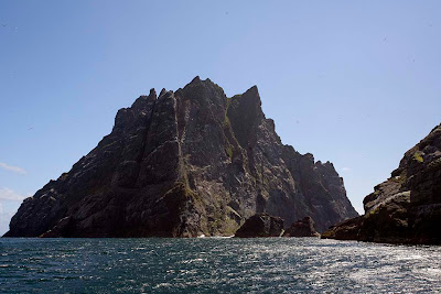
Cuma now made her way down the east coast of Boreray. As we entered the shade of her high cliffs, a chill descended on our mood. We knew we were shortly to return to Harris and leave the enchanted archipelago of St Kilda in the middle of the dreaming ocean.


In reality, the St Kildans lived brutally tough lives there was little romance about their survival or their eventual evacuation. The whole island history has been viewed through the rose tinted spectacles of Victorian tourists. Because the islanders were the remotest community in the British Isles and their economy was based on shared labour without money,they were seen as a utopian curiosity. As a result, their decline and fall was well documented but any seakayaker who has spent time exploring the Scottish coastline will have found dozens of other abandoned settlements. Their residents have no history, no names, no photographs and no rows of books on library shelves dedicated to their lives and times. The only testaments to their existence are a few piles of moss covered stones.

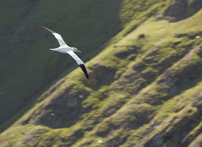
Both my wife and I, who are urban Scots, have ancestors who lived in the isles. My mother's family abandoned their croft on a Scottish island and came to Glasgow in the 1860's, before the stone cottages on St Kilda were built and 70 years before it was evacuated! The reason the St Kildan's survived so long, was the birds. The harvest of the sea fowl made the St Kildan's lives easier than those of many of their peers on the Hebrides and remote mainland coasts.


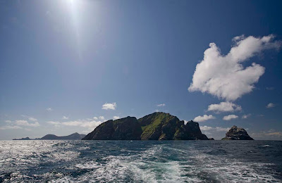
Cuma now turned her bow towards Harris and slowly...


... the jagged cliffs and peaks of the St Kildan archipelago...


... slipped away below the western horizon.

We could, of course, choose to return any summer and I am sure we will. For most of the St Kildans, who were evacuated on that day in 1930, it was to be different. Theirs' was a final farewell, as the peaks of their island home were swallowed by the empty flatness of the Atlantic Ocean.


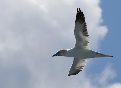
Soon the only evidence, of this land at the edge of the World, were the gannets. They all flew in the same direction, back towards distant rocky ledges and their hungry chicks.

03/06/2008 pm

Winter


No seakayaking today!

Saturday, February 07, 2009

Stac an Armin


Cuma made her way north up the west coast of Boreray and we came to the giant Stac an Armin, at 196m, the tallest of all the British sea stacks.


Stac an Armin is the norther outlier of the St Kildan archipelago looked SW to distant Levenish, Stac Lee and Hirta.


The St Kildans built about 80 cleitean on Stac an Armin.


After rounding the north end of Stac an Armin Cuma made her way SE down the east coast.


The Cuma kept well clear of the rocky channel between Boreray and Stac an Armin. We got a good view of Stac Lee, Hirta and Soay through the gap.


Leaving Stac an Armin in our wake, we looked in awe at the great horns of rock on north cliffs of Boreray. Our visit to the archipelago was soon coming to an end.

03/06/2009 pm

Thursday, February 05, 2009

The west coast of Boreray.


The MV Cuma made her way between Stac Lee and the rugged west coast of Boreray in the St Kilda Archipelago. The island is 384m high, 1.6km north to south and 1.1km at its widest, east to west.


Latterly the islanders kept sheep on Boreray but, in earlier times, they also cultivated the land. Their old lazy bedsare still visible when the low sun strikes across a grassy slope.


Boreray's wild west coast is today inhabited only by the birds.


Gannets peel off every ledge...


... and scan the sea below for fish. They plunge from on high in pursuit of their prey.

03/06/2008 pm

Wednesday, February 04, 2009

Stac Lee


Approaching Stac Lee, every ledge appears to have a thick layer of snow and the sky above seems to be full of swirling snow flakes.


As you get closer, you are confronted by one of the natural wonders of the World. The island is completely covered in noisy gannets. A fifth of the World's northern gannets breed on these isolated blades of rock.


Gannets are large birds with forward facing eyes. They dive from about 50m above the water and can plunge deep under the surface with folded wings in search of fish.


From the side, Stac Lee can be seen to be a thin blade of rock, 172m high. It is remarkable that a party of St Kildans survived here for 9 months (through a winter). They were marooned because a small pox outbreak on Hirta prevented their fellow islanders from picking them up after a bird hunting expedition. Soay is on the horizon.


Looking from the far side of Stac Lee, back towards Dun and Hirta.

03/06/2009