Monday, September 22, 2008

The coral island of Loch nan Ceall, Arisaig


We continued on our way through the skerries of Loch nan Ceall as the wind began to pick up.


We came across another island and took a further break.


Photo JLW

The whole beach was composed of coral sand.


The "coral" is actually the bleached skeletons of the red algae, Lithothamnium calcareum.

14/09/2008

Sunday, September 21, 2008

Eigg shells at Arisaig


We returned to the reefs that guard the mouth of Loch nan Ceall at Arisaig.


The sentinel Sgurr of Eigg acted as a reference point as we lost ourselves in the maze of channels.


Huge expanses of shell sand were exposed by the spring low tide.


We lost ourselves looking for shells.


The beaches here are composed of the fragments of shells of billions of sea creatures that have lived here. The odd shapes in the bottom left are Scottish "coral". The "coral" is actually the bleached skeletons of the red algae, Lithothamnium calcareum.

14/09/2008

Saturday, September 20, 2008

Praise the dawn but be prepared to leave paradise.


Dawn broke with a red sky, a warning for sailors.


A freshening SE wind blew into our bay.


We prepared to leave our paradise in the Sound of Arisaig....


...and continued on our adventures.

24/09/2008

Friday, September 19, 2008

Pocket Surfer 2 review


Photo by JLW

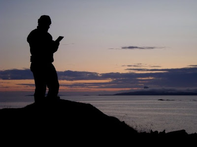
Sea kayaking in remote places is very weather dependent. The weather forecast is therefore vital in safe route planning. On the wild parts of the west coast of Scotland you are lucky sometimes to get AM or sometimes even FM radio reception but the times of the main shipping forecasts are at the unholy hours of 0048 and 0520 hours. A marine VHF transceiver will pick up the coastguard MSI broadcasts every 4 hours, if you are in range (and if as at present the coastguard are not on industrial action and therefore not making the broadcasts). I invariably find I remember the weather forecast time just as it finishes!

Imagine, were ever you were, if you had full Internet access, even to feature rich graphical web sites such as XC weather? If you are a gadget freak like me, you will have tried WAP on a 2G phone and decided that it is hopeless. You will also know that there is no 3G coverage on almost all of the west coast of Scotland.


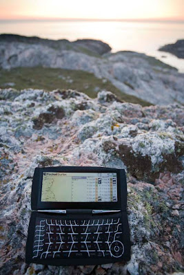
Pocket Surfer 2 has full Internet access in this remote spot.

Let me now introduce to you the Pocket Surfer 2 from the Canadian Datawind company. I have been using it since December 2007 with great success. Pocket Surfer 2 connects to the Internet using the 2G GPRS network via a built in SIM and antenna. This is not the WAP version of the Internet but the full version. Even complex web pages with hi res photos will download in less than 30 secs and text rich pages will often download in a few seconds. This is done by connecting to the Internet via Datawind's servers which compress the page before transmitting it to the Pocket Surfer over the GPRS network. This does mean that the photos are very grainy and that videos will not download but other multimedia such as Flash and Java do work. As you are accessing the Internet through Canada, you get the Canadian version of Google by default but this is a minor quibble.

Features and functions
It is a slim, clam shell gadget which when open reveals a 640x240 pixel colour screen and a full qwerty keyboard which is easy to operate with two thumbs. The keyboard is illuminated so the device is usable in the dark. The "mouse" pointer is navigated by a group of four direction keys. Sometimes you might loose sight of the "mouse" pointer but if you direct it to a corner of the screen, it is easy to find again. It is a surprisingly practical solution to navigating web pages on a compact, hand held device. The only type of web site I have had difficulty with is where a drop down menu has a long list of options, which extend below the bottom of the screen. The device will not let you drag a scroll bar down by left clicking and dragging the bar. An example is MagicSeaweed's surf locations. I have got round this by creating a web page with multiple hyperlinks direct to the each of the surf location pages I regularly access.

The device has a built in LION battery (with a mini USB charge socket) which lasts about 4 hours per charge. It comes with a mains to mini USB charger but you can also charge it from a computer USB socket with a USB cable. I have also charged in the wild with a wind up mobile phone charger with a mini USB socket. It is a dedicated Internet browsing device and so cannot make phone calls or be connected to a computer for USB data transfer. By concentrating on this function it does so in such an efficient manner that it will download web pages even quicker than a G3 iPhone in the city! Actually it has another function. There is a built in GPS receiver which shows your current position on Google maps. You can then click for information on a variety of local attractions!

It is also easy to access your email including attachments such as word docs, access online storage, remotely access your work computer etc. but I do not! You can use https sites for banking. Datawind claim that the link over GPRS is encrypted but I have not trusted my bank details yet. Maybe in an emergency I might and my data would probably be less likely to be hacked than in an Internet cafe. It will not work with video or audio or online games because of the compression used before a web page is sent over the GPRS network. What it does do it does very well indeed. It allows you mobile access to Internet information in places with no WIFI or 3G and it accesses it faster than any other GPRS or 3G device I have seen.

Where does it work?
For outdoors people who need Internet access for weather forecasts, the Pocket Surfer 2 has no competition. It has worked on islands off the west coast of Lewis and Harris. The Monach Islands, half way to St Kilda, Skye, Arisaig, Scarba, the remote SE coast of Islay, Sanda and the Solway. Sometimes you might need to climb a small hillock to get a signal, other times it will work at sea level. On our recent trip to St Kilda on MV Cuma, the skipper Murdani, who has a lifetime experience of working these waters, was delighted to be able to access his favourite weather web pages. We were waiting on the Monach Islands for a break in the weather to get out to St Kilda. He said "In all my years I have seen nothing like it, who would have thought it? The Internet on the Monachs!" I have also used it while waiting at airports and railway stations. On a moving train it works great until you go into a tunnel!

Cost
Now the catch, what about the cost? I bought mine for £180 and it is now £160. Well, now the really good news: this also includes 20 hours per month browsing. In subsequent years you get 20 hours a month browsing for £40 per year.

Support
What about after sales support? After 9 months, mine developed a minor fault with the screen that made it difficult to read the menu bar. An email to the UK support site was answered within 5 minutes. They said it was a known fault with some of the early models and replaced it under warranty. What more can you ask for?

Conclusion
I cannot begin to tell you how much I appreciate such easy access to the Internet in wild places. I know some purists will say they go to the wilderness to escape from all that but accurate weather forecasts are a great contribution to safety and I am a cautious sea kayaker.

The Pocket Surfer 2 is a unique device. It may not be perfect but nothing else comes close for full Internet access in wild places, so I am afraid I will need to award it 12/10!

Thursday, September 18, 2008

End of an Eigg day


At the end of the day...


...nothing beats a good campfire. As the glow of the setting sun left the sky, the dark rocks were illuminated by the glow of the fire.

We bought a sack of logs at a garage in Fort William and built the fire on the sand below the HW mark. There was no trace in the morning.

13/08/2008

Wednesday, September 17, 2008

The Golden Eigg of Arisaig


Sunset is a magical time to be on the water. When the skies cleared there was a mad scramble for the kayaks...


..in the rush to be on the water....


...as the sun set behind the distinctive outline of Eigg.

13/09/2008

Tuesday, September 16, 2008

Sunset over the Sea of the Hebrides


It was a relief when the rain stopped. We were by now famished and we were able to enjoy our evening meal in the dry.


After a post prandial Guinness, I decided to climb a hill to get a photo of our little bay. The colours of the bronze and gold autumn bracken and the turquoise water over the white shell sand beach leaped out of the surrounding landscape of gray rock and sky.


Then I crested the ridge. To the west, the clouds were breaking and the mists were curling and lifting round the Sgurr of Eigg which rose out of the burnished gold of the Sea of the Hebrides.


As if this was not enough, the clouds began to lift from the mountainous isle of Rum, which lies beyond Eigg. Its mountain tops have dreamy names like Sgurr nan Gillean, Ainshval, Trollaval, Askival and Hellival. Seeing them floating above a sea of cloud told us we had truly arrived in sea kayaking heaven.

13/09/2008

Monday, September 15, 2008

Arrival in the Sound of Arisaig


We paddled on through the rain and drizzle and eventually arrived at a sheltered cove protected from the swell by offshore skerries.


We erected the tents in the rain but as we started to carry our gear up from the boats that golden glow on the horizon began to grow.


As Ardnamurchan Point came into view our hopes were raised for a dry night and even a sunset!
13/09/2008

Sunday, September 14, 2008

Midges and rain but no French gold in Loch nan Ceall


Seakayakphoto.com is delighted to welcome a new staff member. Alastair joined a sea kayaking trip in desperate search for fair weather despite an atrocious forecast. After a long drive to Loch nan Ceall near Arisaig, the mist was hanging low over the sea. It was the Scotch variety; a very fine but wetting rain and infested with midges. "We must be mad!" was the general consensus.


Once on the water it was slightly better, at least the midges had not followed us but the prospect of a sodden camp did not hold much attraction.


We paddled below a raised beach. The cliff behind was riddled with caves. We landed to explore an interesting one. In 1746 two French warships landed gold to support the Jacobite cause after their defeat at Culloden the year before. The Royal Navy blockaded the ships and some Frenchmen escaped with the gold on land. It was never found and is reputed to be hidden away in this area.


We climbed up to the cave. Its sheltering wall meant it was dry as a bone but despite a careful search no gold was found. We found some neatly carved graffiti from 1936 but nothing else. We had wondered about using the cave as a doss for the night but the smell of beasts was unappealing.


We paddled on under low clouds and rain but an occasional golden glow on the western horizon promised better...

13/09/2008

Friday, September 12, 2008

A residence on Scarba


After our exertions we were ready for a rest. We came across an old keeper's cottage high above a bay of slippery cobbles on Scarba's southern coast.


Despite having a sound roof with recent double glazing to the south, it was dusty and damp. Tony and I didn't find the atmosphere within conducive to a good night's sleep.


So we retreated to the shore where we pitched our tents. The souls of lost sailors are reputed to roam the coast of Scarba at night. Well it wasn't lost souls that bothered us. It was the double whammy of midges and ticks.

30/08/2008

Thursday, September 11, 2008

The Great Race of Corryvreckan


We paddled down the exposed west side of Scarba.


Jura lay far to the south.


As we approached the Corryvreckan, plan A did not seem quite such a good idea. Plan A involved sticking close to the Scarba shore and using an eddy to carry us into the Corryvreckan against the full force of the flood tide. As you can see, a slight swell made the edge somewhat rougher than we (fair weather paddlers) choose to paddle in.


We entered the Corryvreckan on Saturday at 1552. Although it was the last hour of the flood, the flow was still running at full belt! The rule of thirds does not apply here!


We found ourselves in a patch of calm water between the eddy and the Great Race of the Corryvreckan. The Great Race extends for 5 nautical miles out to sea. It is not a place to get into trouble.


It was with some pleasure and dry mouths that we found ourselves paddling into the shelter of the Great Gulf of Corryvreckan.

30/08/2008

Wednesday, September 10, 2008

A sudden tidal surge on Scarba


When we left Guirasdeal we went into the Grey Dogs tide race (against the tide) for a little fun.


Somewhat scared witless, we proceeded down the NW coast of Scarba.


The photo above shows the nice calm conditions which we found there, after the mayhem of the Dogs.


We landed for a short break and carried the boats well up the beach (about 3 boat lengths on a steep beach).

We only turned our backs for a minute while I attempted to get a weather forecast on my mobile phone. (The coastguard were not broadcasting the forecasts due to industrial action.)

In that moment a tidal surge came in and carried the boats off the beach where they were bashing around the rocks. The strong offshore wind threatened to take them to the Garvellachs. We leaped into the sea and recovered them just in time.

We knew about these surges in this complex tidal area but had not been careful enough. Be warned and carry your kayaks above the high water mark on even a short stop.


Despite our apprehension of what conditions would be like in the Corryvreckan, we left the storm beach on Scarba wiser and somewhat relieved!

30/08/2008

Tuesday, September 09, 2008

The spirits of Dunyvaig Castle, Lagavulin Bay, Islay


Leaving Port Ellen and heading east along the south coast of Islay we came across a break in the reefs guarding a large bay.


Being highly skilled sea kayakers we were able to use all our powers of navigation to deduce that we were now in Lagavulin Bay.


In the thirteen century the bay was the anchorage for a fleet of armed birlins. They were the navy of the Lords of the Isles who were descended from Somerled, who had wrested the Hebrides from the Vikings.


Today the 16th century ruins of Dunyvaig Castle teeter on the edge of a rock stack which guards Lagavulin Bay. Some of the castle dates back to the thirteenth century and its stones have been there so long that it appears to grow out of the rock. In places it is difficult to say whether the structure is the hand of man or the hand of God.


The castle changed hands many times in a turbulent history and in the 17th century one of its last MacDonald owners was hanged from the walls after a siege. Some say it is haunted by troubled spirits from its bloody past. We chose not to camp there but the only spirit we found was a heady vapour making its way over the sea from a plain white building at the back of Lagavulin Bay.

14/07/2008