Monday, February 26, 2007

Inchmarnock's beach of treasures.


Our weekend trip to Inchmarnock in the Firth of Clyde was blessed with stunning light.


We landed on a lonely beach which was patrolled by a golden eagle.


We were not the only ones disturbing the eagle's domain. Herring gulls were mobbing it.


The beach was full of treasures. The pink pebble is rhyolite which was transported here from Buachaille Etive Mor, nearly 100km to the NNE, by glaciers in the last ice age.

Sunday, February 25, 2007

Another fabulous day on the Clyde


Flat calm start to the day.


We took the ferry to Bute then headed over the West Kyle of Bute to Ardlamont Point on the mainland.


We then headed down pat the west side of Inchmarnock before heading back to Bute.


Of course it did not stay calm and we had a brisk paddle into the wind for the last 9km.

It does not end there. I got the car stuck in the mud just as it was getting dark and the rain started and we only had 30 mins to catch the last ferry! Fortunately a friendly farm lad came with a very large JCB and pulled me out with a huge chain. (I had my tow hitch on.) We made the ferry by the skin of our teeth.

What a day!

Rum rocks.


The north coast of Rum is a wild place.

Friday, February 23, 2007

The Witch's Step, Arran


I recently posted about the sea level Bad Step on the Island of Skye but there are many more high level bad steps such as Ceum na Caillich (or the Witch's Step) on the north west Glen Sannox ridge in the Isle of Arran.

The view from this ridge is a simply stunning mixture of rock and sea scapes and makes for a scrambling paradise.


We recently paddled below Arran's lofty ridges and I have now posted the complete picture set over at the Scottish Seakayaking Photo Gallery.

Thursday, February 22, 2007

Mackerel sky.


"Mackerel sky, mackerel sky - never long wet, never long dry. "

Is there any truth in this piece of folklore?

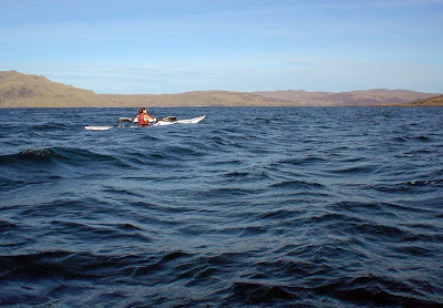
A mackerel sky is composed of patches of altocumulus cloud. It represents a layer of unstable and humid air which often follows a ridge of high pressure and precedes a warm front by about 400km. As warm fronts move about 50km/hr you can expect a change in the weather in about 8 hours. This was taken at 11am on our trip from Loch Sunart to Mull on 18/2/07. The wind picked up to force four from the SE by 12:00. By 14:00 the wind had increased to force 5 and it clouded over by 14:30. It was raining by 23:00.

On Saturday 17th February, when we were planning our trip, Scotland was under a ridge of high pressure and there was no wind. Sunday 18th dawned clear and still but the BBC forecast for Tobermory and Mull was for 17mph SE winds. The met office inshore forecast issued at 0600 UTC on Sunday 18 February 2007 for Mull of Kintyre to Ardnamurchan was:

Wind southeasterly 5 or 6, occasionally 7.
Precipitation: rain then showers.
Visibility: moderate or good.
Sea state: Moderate occasionally rough.

Although apparently sheltered, the Sound of Mull can be very rough especially in wind against tide conditions. LW Oban was at 12:35, 1 day before springs. Streams in the Sound of Mull change at HW and LW Oban. The flood flows to the NW and the ebb to the SE. When we crossed the Sound we had force 4 SE wind against the last hour of the ebb and it was rough in the middle. Although the wind was forecast to increase later, we enjoyed our stop at Tobermory as I knew that by that time the flood would have started and being with the wind, it would flatten the water. This is exactly what happened.


The white horses disappeared and the water flattened as the flood built up speed. We had a trouble free paddle back to the shelter of Loch Sunart.

Wednesday, February 21, 2007

Decapitation at Camas nan Liath!


On our recent paddle in Loch Sunart and the Sound of Mull we enjoyed an idyllic stop at Camas nan Liath. From a distance the cobbles on the beach looked grey and I thought that was the explanation of the Gaelic name which I took to be "beach of the grey" though I though just Camas Liath would have done.


The water was crystal clear and beckoned us in to the beach which, nestled under the steep wooded slopes of Tor nan Con. Even in winter, the colour of the birch and aspen branches contrasted with the grey of the cobbles and invited a return in spring.


To the north west, the beach is exposed to the full force of Atlantic storms and the bed rock had been worn into mounds, hollows and channels by the action of countless wave tossed cobbles.


In the deeper hollows, at the bottom of each crystal clear pool of water, there was a mixture of cobbles and pebbles of different sizes and rock types.


As we left, we paddled past great grey "heads" of rock whose necks had been worn away by the wave action. Some of the older heads had been decapitated and fallen as boulders. Suddenly, the full and subtle meaning of the Gaelic "Camus nan Liath" hit me: Beach of the Grey Heads.

What a place, what a language.

Tuesday, February 20, 2007

Mishnish mission via Morven to Mull from Ard na Murchan


We started in the shelter of Port na Croisg, Loch Sunart with the grentle hills of Morven receeding in the distance.


Our route was 28km. Coming back over the Sound of Mull the tide was strongest towards the Morven shore.


Tobermory was founded in 1788 by the British Fisheries Society to service the herring fleet. It is named after tobar Mhoire or Mary's well. In 1588 the Almirante di Florencia, a galleon of the Spanish Armada blew up in the bay. She was reputedto be carrying thirty million gold ducats.


At low tide the beach is sand and shingle. At high tide there are a couple of slipways. There is a small one conveniently situated beside a blue fish and chip kiosk at the pier in the middle of the bay (beside the distant red house in the upper photo.