Imagine you are at the edge of the sea on a day when it is difficult to say where the land ends and the sea begins and where the sea ends and the sky begins. Sea kayaking lets you explore these and your own boundaries and broadens your horizons. Sea kayaking is the new mountaineering.
Pages
▼
Tuesday, December 30, 2008
Ebb tide in the Lynn of Lorn
Although the sun was now shining on the Morven summits the Appin shore was still gripped by frost and shade. The Sgeir Bhuidhe lighthouse lies just offshore. It was built at the end of the 19th century but by 2001 was badly in need of replacement. The Northern Lighthouse Board were originally going to replace it with a standard rectangular structure but fortunately sense prevailed and the replacement was modelled on the old structure. The light has two flashes every seven seconds with white and red sectors. The original lantern is now on display in the village.
Jennifer and I ferry glided out into the ebb tide in the Lynn of Lorn. The 5km/hr current soon carried us away down the Lynn leaving the little Isle of Shuna far behind. Note that there is another Shuna 42km further SSW, to the east of Luing.
Alan and Tony were still in the shade as early morning mist hung over the wooded shores of Appin.
Then at last the sun cleared the hills and David and Phil were left blinking in its strong light. With a fair tide we were now off on our 37 km circumnavigation of Lismore.
27/12/2008
Monday, December 29, 2008
Port Appin dawn
Port Appin is a sleepy little village which nestles below the mountains of Appin which seperate Loch leven and Loch Creran on Argyll's rugged west coast. Port Appin was never a fishing port but it served as a stopping point in the 19th century for steamers travelling between Glasgow and Edinburgh via the Crinan and Caledonian canals.
Today it serves two small ferries. This is the Lismore which carries foot passengers across the Lynn of Lorn to the beautiful island of Lismore. In Gaelic, Lismore means the big garden. It is more fertile than many of the Scottish islands because of the presence of limestone rock. From 1800 till 1934 this was quarried and heated in lime kilns to produce lime for agriculture on the west coast and building in Glasgow.
The quarrying tradition in these parts started again in 1986 when the Glensanda quarry opened. It is one of Europe's biggest quarries and its granite rock was used to make the channel tunnel. Glensanda quarry is removing an entire mountain, Meall na Easaiche, on the Morven coast on the far side of Loch Linnhe, beyond Lismore. It is situated just behind the mountains in the sunshine in the photo above. Another ferry carries local workers from Port Appin across Loch Linnhe to Glensanda.
We were bound for a circumnavigation of Lismore and also chose to launch from Port Appin. We carried the boats over frost covered seaweed in the predawn light. Although we were still in freezing shade, there was a lovely pink glow in the sky reflected from the tops of the high mountains which were already in sunshine.
We planned a clockwise circumnavigation. It is 37 km and we knew that it would be dark before we finished as sunset would be about 15:34.
On 27/12/2008 HW Oban was at 05:35 and 17:49. The tidal constant at Port Appin is -00:05 Oban. It was one day before springs.
At the Lynn of Lorn south end (1 knot springs), the ebb (SW) starts at -01:40 Oban which was 16:09 on our trip. The flow (NE) starts at +04:45 Oban which was 10:20.
At the Lynn of Lorn north end (2.5 knots springs), the ebb (SW) starts at -00:15 Oban which was 17:35. The flow NE starts at +06:00 Oban which was 11:35.
On the NE going flood an eddy runs SW from the islands along the SE coast of Lismore so we reckoned we would have tidal assistance for most of the day.
27/12/2008
Sunday, December 28, 2008
Less is more!
This is another post for the benefit of our Canadian friends, who might have had their illusions of sunny and calm Scottish seas shattered by the recent series on the Mull of Galloway. Relax, here we are enjoying our second of three luncheons in balmy December conditions!
Some of the staff at seakayakphoto were concerned about the effects of Christmas overindulgences on our 24 pack abdomens thus affecting the tailored fit of our dry suits.
Alan, Tony, David, Phil and Jennifer.
We set off at sunrise on a little 37 km jaunt. Unfortunately all this exercise made us rather hungry.
We paddled well past sunset into the darkness. We might not have lost any weight but what a fantastic day!
27/12/2008
Tuesday, December 23, 2008
Portencross Castle to Little Cumbrae island.
We set off from near Portencross Castle on the North Ayrshire coast. Our plan was to cross to Little Cumbrae island then over to the south end of the island of Bute.
Grey clouds hung low overhead but in the distance, behind David and Phil in the double, the horizon was sunlit from the south Ayrhire coast to Ailsa Craig and Arran.
We soon crossed the shipping lane and made for Gull Point at the south end of Little Cumbrae. We followed in the wake of a yacht with a traditional gaff rig. She had her topsail set in the light wind.
14/12/2008
Monday, December 22, 2008
Port Logan Inn
Leaving the Mull of Galloway we drove north to where we had left the shuttle car. We were bound for Port Logan on the west coast of the Rhinns of Galloway. The cars were shaking in the car park as we looked out to the windswept sea.
We had driven right past the Port Logan Inn. This is a truly convenient sea kayaking pub. You can paddle up to within a few yards of the door and in summer sit at the outdoor tables and watch the sun go down behind the now empty stone tower of its former lighthouse.
There was a decided nip in the air so we decided to make use of the interior facilities. A roaring fire greeted us and we were soon ensconced within its circle of warmth. The barman said:
"Sorry you didn't get out lads."
"Oh but we did!"
"Where on earth did you get shelter on a day like this?"
"We just nipped round the Mull of Galloway."
"The Mull? The Mull o Gallowa? Yerra right pair o' eejits!"
"Maybe so barman, but we're thirsty eejits!"
Fortunately the Port Logan Inn is stocked with a very extensive and fine range of refreshing liquids. Indeed, if you ask very nicely, a bottle of Fraoch Leann might even be produced from under the counter!
All in all, the Port Logan Inn meets the very highest standards required to be called a sea kayaking pub!
15/12/2008
Sunday, December 21, 2008
The spell of the nine tides!
The complex tide races of the Mull of Galloway change by the minute and can catch out even experienced sailors. Many years ago a Galloway witch sought to undo the good work of the fairies of the cave who looked after sailors in peril. She had been spurned by a particular sailor so she spun a spell that wove nine tides to entrap him at the Mull.
But the sailor heard about her spell and, from that day onwards, he always pulled his boat over the Tarbet and avoided the Mull. He was never caught but the spell of the nine tides is still in place today.
15/12/2008
Saturday, December 20, 2008
A drink made from some unknown kind of fog!
The foggy ramparts of the Mull of Galloway were the scene of the final battle between the Scots and the last of the Picts of Galloway. The Picts had managed to repel successive waves of invaders including the Romans and the Anglo-Saxons. How could this warrior race have been defeated by the Scots? One reason for their down fall may have been their secret brew! A Scots historian wrote: "The Picts brewed some awful grand drink they ca't (called) Fraoch Leann from heather and some unknown kind of fog". The Scots king coveted the recipe for this heather ale and was determined to get it from the last surviving Picts.
The Scottish writer, Robert Louis Stephenson, was the grandson of George Stephenson, who had built the Mull of Galloway lighthouse in 1830. R.L. Stephenson had visited Galloway on a walking tour and had heard of the legend of heather ale. He composed a poem based on the story called “Heather Ale: A Galloway Legend”. In it he has a pretty good idea of what led to the Picts’ downfall.
“They brewed it and they drank it,
And lay in blessed swound,
For days and days together,
In their dwellings underground.”
After the battle, the king of the Scots tortured an old man and his son, who were the last two survivors of the battle. The king said he would spare one of them, if he was told the recipe for Fraoch Leann. The old man knew they were both doomed and blurted out, “Spare me, and I will tell you!” So the son was thrown into the sea below the Mull.
The king again demanded the recipe but the old man said, “I feared my son might tell you to spare me”. R.L.S. continues the story:
“But now in vain is the torture,
Fire shall not avail:
Here dies in my bosom
The secret of the Heather Ale."
The old man leaped over the cliff after his son and the Galloway Picts and Fraoch Leann were apparently no more....
15/12/2008
Friday, December 19, 2008
End of the road: the Mull of Galloway tide race.
After we reloaded the kayaks onto the car, we drove to the road end at the Mull of Galloway, the southernmost tip of Scotland.
Looking east on the spring ebb tide you can see the main race comes very close to the east end of the Mull but it then heads SW, out to sea, leaving most of the cliffs below the Mull standing in a relatively flat eddy.
This is the spring ebb race running against a force 4 to 6 SW wind.
Looking south towards the Isle of Man over the ebb race.
Looking west, the ebb race is well offshore...but the water round Gallie Craig is not exactly flat.
To give an idea of the scale this is Gallie Craig from the sea looking east towards the lighthouse! (17/02/2008)
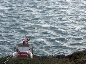
The above photos show the ebb race. The flood race come much closer to the cliffs than the ebb. We went through against the flood tide, 2 hours from slack water at springs. This photo (in a similar wind to that which we experienced) shows the water state below the fog horn, 2 hours from slack water at neaps. It gives an idea of what we met. We found more broken water and the conditions persisted without a break for 2km! To give some idea of scale, the photo was taken from a height of 71m. (28/12/06)
Going east to west, on the west going ebb you have only a short 100m or so of race to cross at the east end of the Mull. After this you enter a large relatively flat eddy which extends right to the west end of the Mull and beyond.
Going east to west on an east going flood as we did, even in close to the rocks, you are much closer to the main race. From the light house you have to fight adverse currents at each headland. The red arrow highlights a submarine reef which throws up standing waves especially on the flood.
What a fun place! No wonder several legends attach to this place.....
PS Of course most people would have driven up to the road end at the top of the cliffs and looked at the race before they paddled it. Many would have decided that one look was enough! The trick with this type of paddling is not to look first! We didn't, but of course I am not recommending this ostrich type of approach to planning sea kayaking expeditions! In truth I knew exactly what it would look like as I have gazed down on the race in many different conditions but not paddled it afterwards.
15/12/2008
Thursday, December 18, 2008
Myths, caves and tides of the Mull.
Let no one accuse the staff of seakayakphoto.com of being mindless thrill seekers! After our adrenaline fuelled circumnavigation of the Mull of Galloway, we set off northwards into the sheltered waters of Luce Bay on the lee of the Rhinns of Galloway. We were bound on a learned voyage to find the Cave of St Medans or the fairies!
We had paddled right past the cave because it is hidden within a deep cleft in the rocks. An outer wall was built across the open end of this cleft and roofed over to form a Christian chapel.
Sir Herbert Maxwell drew this view in 1885. The outer wall of the chapel has deteriorated over the last 123 years. In the 1825 an archaeological dig unearthed a prehistoric human tibia in the cave and in the chapel, 12th century coins from the reigns of Kings Alexander and David of Scotland.
This is the present day view from the door of the chapel, just where the figures in Maxwell's drawing are standing. Apart from the corner wall of the chapel, which has crumbled so that you can't see where the window and door were, the only change is the low roof of the Gallie Craig visitor centre which is right on the horizon of the Mull, to the right of the lighthouse.
Tony explores the cave at the back of the chapel.
Modern but rusting ironwork supports the door lintel. The cave was remarkably warm and dry.
The oldest inscription we found was AD 1850.
Of course the Christian Church has long built on ancient superstitions and pagan places. The cave was originally known as the Fairy Cave. Sailors of old would leave offerings of food to ensure fair winds and tides for a safe passage round the Mull. It was not advised to wait for the fairies to come out of the darkness of their cave and watch them gather these tokens of maritime respect. The mere sight of a fairy, by even one sailor, could prove bad luck for an entire ship. Apparently a hermit led a pretty comfortable and very well nourished life in the cave for many years. I threw the last of my lunchtime sandwich towards the mouth of the cave but a hungry gull proved faster than any fairy!
We had of course planned this day all wrong. We should have paid our (edible) respects at the cave before starting our voyage round the treacherous tides of the Mull. Frankly, after such disrespectful behaviour towards the fairies' nutritional needs, we were lucky to get round the Mull in one piece but we learned a lot!
15/12/2008
Wednesday, December 17, 2008
What a carry on at Tarbet!
Made it! Our relief at rounding the Mull was palpable. We landed in west Tarbet Bay and there was a unanimity in our decision not to head further north to Port Logan, where we had left the shuttle car. The forecast was for force 4 to 6 winds gusting to 37 knots by evening but the front had obviously arrived early.
There are several places in Scotland called Tarbet or Tarbert. It comes from the Gaelic word Tairbeart. In modern Gaelic this means isthmus but its origin lies in "over carry". These isthmuses were where the Vikings carried their longships overland from one side of a peninsula to the other.
Olaus Magnus 1555
This often avoided a dangerous voyage round a headland but it was also a way of claiming land! The Vikings reached a truce with the Scots, which allowed them to rule any "islands" they could sail (or drag) their boats round!
Olaus Magnus 1555
From a distance the Mull of Galloway looks like an island as the Tarbet is low enough to be under the horizon. The day was yet young so we decided to carry our kayaks Viking style over the 0.45km distance and 21m height of the Tarbet. It was hard work, as unlike the Vikings, we had set off unarmed and were so unable to persuade any locals to assist us in our endeavours.
The boats were soon on the beach of east Tarbert Bay but we needed some lunch before heading out again!
15/12/2008
Tuesday, December 16, 2008
Southern exposure round the Mull of Galloway.
The Mull of Galloway is a bold headland which juts out into the North Channel of the Irish Sea. It is Scotland's most southerly point. It is a magnet for sea kayakers due to its notorious nine tides!
Tony and I set off from the East Tarbet of the Mull of Galloway 2hrs and 30mins before the end of the east going flood. We planned to use a west flowing eddy that runs close into the cliffs. Unfortunately this eddy does not run round each of the many headlands on the Mull and we were prepared to battle round these into the teeth of the east going flood. The freshening SW wind began to make its presence felt. Cats' paws spread out on the water as the wind dropped over the cliffs.
We soon picked up an east going eddy which runs along the north coast of the Mull. It carried us effortlessly to the east point of the Mull.
Here in the shelter from the wind, and out of sight of the race, we enjoyed a calm moment enjoying a view of the Isle of Man. Calm was not a word we would use again on this trip!
As we worked our way round the corner, the water became livelier...
... and the wind began to increase.
This photo was taken in the last of the calm water before we entered the race. The water then got a bit rough and I found myself quite unable to take further photographs....
We were in the disturbed water from below the lighthouse to the entrance of West Tarbet bay. Most of the waves were only about 5 feet, crest to trough, but they were short, steep, breaking, very irregular and coming at us from all angles.
As the wind shrieks round their jagged ramparts and as the surf thunders at their base, no one can hear your screams far below the cliffs of the Mull of Galloway!
Close to the rocks the clapotis was fearsome but the tide was less strong. After being side surfed by several waves we kept away from the rocks as much as we could. As a result we found ourselves in the stronger adverse current further out. It took 40 minutes from the east to the west points of the Mull. It is only 2.5km so we actually managed to average 3.75km/hr. It really was sustained maximum effort all the way. The worst bit was 1.5km to the west of the lighthouse. My GPS showed I was going backwards at 1km/hr on several occasions before I got round that one! The maximum speed I hit was 14.5km/hr (while still paddling) in the eddy to the south of the lighthouse.
The wind was still increasing and any thoughts of continuing up the west coast to Port Logan were abandoned. We made for the shelter of West Tarbet Bay and prepared ourselves for a Viking style portage over the Tarbet ...
15/12/2008
Monday, December 15, 2008
Tempestuous seas!
I would like to extend a very warm welcome to Trans Atlantic readers of this blog from Newfoundland and Labrador! Thank you for the link Alison.
These hardy souls have to endure some of the most challenging sea kayaking conditions on the planet and are obviously envious of us Scots, sitting here in the balmy Gulf Stream!
However, I would like to point out that it is not all glassy calm seas and glorious sunsets! Somewhat embarrased by Alex's reference to "Tempestuous Seas" (greetings Alex :o) ), today Tony and I decided to salve some Scottish pride and go where the water is seldom glassy calm... the Mull of Galloway! After all, it is just about the shortest day, there was a windchill of minus 2C, a big spring tide and a force 4 to 6 SW wind, what better way to spend a few hours than rounding the Mull of Galloway?
15/12/2008