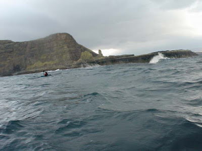
Imagine you are at the edge of the sea on a day when it is difficult to say where the land ends and the sea begins and where the sea ends and the sky begins. Sea kayaking lets you explore these and your own boundaries and broadens your horizons. Sea kayaking is the new mountaineering.
Pages
▼
Sunday, December 31, 2006
Sea kayaking desktop photo calendar 2007.
January
Looking northeast from Sgeir a'Ghail, Loch Nevis, to Knoydart.
February
Cailean Macleod at Coldingham Bay, Scottish Borders.
March
The distant Cuillin mountains of Skye are seen to the south west from Eilean Stacan, Loch Carron.
April
The Scarba shore of the Gulf of Corryvreckan at slack water. 15 minutes later we were doing 18km/hr without paddling!
May
No, it's not Scotland! It is the wonderful reef of Les Ecrehous 10.5km NE off the NE corner of Jersey in the Channel Islands.
June
Looking towards the grey hills of Lewis from Scarp.
July
The entrance of Loch Rog, Lewis.
August
The Sound of Harris from Bearnaraigh.
September
Sea stacks at Cliobh, Lewis.
October
Paddling out to Bearasaigh and Seana Chnoc, Lewis.
November
The tidal Clachan Sound runs under the "Bridge over the Atlantic", Nether Lorn.
December
Sunset down the Sound of Jura from Loch Caolisport, Knapdale.
The photos here on Blogger are 640x800. If you would like high resolution 1024x1280, 1024x768 or 800x600 copies, please visit the Scottish Sea Kayaking Photo Gallery.
May 2007 be good to you.
Year's end.
Friday, December 29, 2006
Gimme Shelter
Oh, a storm is threatning
My very life today
If I dont get some shelter
Oh yeah, Im gonna fade away
-"Gimme Shelter", Rolling Stones
These snails had gathered for shelter under an overhanging brick on the outer wall of the Mull of Galloway lighthouse vegetable garden. The wall is exposed to the prevailing wind and is perched on the cliff edge 80 metres above the surging tides below.
Lighthouses were built to guide mariners away from treacherous coasts to safe haven. I am not sure why we were attracted there on such a day as yesterday. The Mull of Galloway lighthouse was finished in 1830 and was built by George Stephenson. It flashes white every 20 seconds. Supplies originally came by sea and were landed at the tidal jetty at East Tarbert. It has been unmanned since 1988.
Like the snails, we did not brave the weather but sought shelter in the Crown Hotel in nearby Portpatrick. We will return to sea kayak the Mull of Galloway another day.
We mulled it over and went to the pub.
The Mull of Galloway lighthouse.
Kenny, Richard, Cailean and myself assembled above the Mull of Galloway tidal race. This is where the flood tide from the Atlantic is compressed as it rushes round the Mull to fill the Solway Firth and the north Irish Sea. When we arrived on 28/12/06, a force 5 SE wind was blowing against the tide. The inshore waters forecast was SE 3 to 4 increasing 6 to 8. It was 4 days after springs. The tidal constant at the Mull is +00:15 Dover. Slack water (close in) is about is about -01:30 Dover.
Dover times were: HW 04:28 LW 11:48 HW 17:11. The Admiralty tidal stream atlas predicted SE flood flows of: 0.5 knots at 11:11; 1.2 knots at 12:11; 2.8 knots at 13:11; and 3.5 knots at 14:11.
11:06
11:30
11:38
11:42
The cliffs are 80 metres high which gives some idea of the scale of the water disturbance.
13:03
As the flood progressed it swung round from flowing to the SE to a more easterly direction. As it did so, the race came in closer to the foot of the cliffs at the east end of the Mull.
It looked nothing like the sunny, calm conditions shown in Scottish Sea Kayaking fifty great sea kayak voyages. We beat a retreat to the pub. Kenny was very disappointed.
Wednesday, December 27, 2006
Sea kayaking portal to a short winter day.
This magnificent Edwardian portal from the Wemyss Bay railway station to the ferry terminal was built in 1903 to carry the holiday crowds from Glasgow to the steamers that went "Doon the Watter".
Bang up to date, CalMac's MV Bute entered service on the Wemyss Bay to Rothesay route in 2005. It took us to Bute and allowed a paddle that otherwise would not have been possible in a short winter day. MV Bute was built in Poland. I am going to try and get a Polish slater to fix my roof.
Tuesday, December 26, 2006
Boys will be Buoys
Both Wenley and Cailean have blogged about buoys today. I thought I might join in too. These two pairs of lateral light buoys are situated in the Kyles of Bute where the navigable channels of the East and West Kyles meet.
Saturday, December 23, 2006
Kyles of Bute
The Kyles of Bute are the narrow channels which separate the Isle of Bute from the mainland. They are a very long way from the open sea and generally tidal streams in the Firth of Clyde are weak but the spring tide runs through the Kyles at up to 3 knots. The "lighthouse" is the An Caladh beacon which is actually lightless. If you do not have time to paddle to Bute from the Ayrshire coast, there is a perfectly good Calmac ferry from Wemyss Bay to Rothesay. Tomorrow is Christmas Eve but it is also a spring tide.......
Friday, December 22, 2006
Eilean Musdile lighthouse
I thought a midsummer sunset behind a lighthouse might brighten a short dark winter day. This is Eilean Musdile light which is at the south end of Lismore and guards the entrance to the Sound of Mull from The Firth of Lorn. Roberst Stevenson built the lightghouse in 1833. It weas automated in 1965. It flashes white for 0.5 seconds every 10 seconds.
It was taken from MV Dundarg, a 1930's fishing boat which was chartered by Andy Spink of Hebridean Pursuits for their Wild West Week, sea kayaking off the west coast of Scotland.
The week lived up to expectations!
Thursday, December 21, 2006
Day dreams in the shortest day.
Today the sun set in Glasgow at 15:44. Tomorrow it will set at 15:45. I do not wish to sound as if I am wishing my life away but summer is now on the way!
This picture was taken in late June when the sun sets at 22:05. We left Glasgow after work on Friday and launched from Arduaine at 21:20. The sun is setting behind Ben More on Mull. That night we camped on Luing. The next morning we went out through the Cuan Sound to the Garvellachs. From there we went to Scarba where we watched the sun set over the great race that extends to the west from the mouth of the Corryvreckan on flood. Kieran recently wrote about this and other whirlpools.
The Corryvreckan lies between the islands of Scarba and Jura.
The summer panorama from the steep slopes of Scarba was simply stunning.
Sweet dreams are made of this.
Wednesday, December 20, 2006
The late, lamented Sony DSC U60
This is my favourite camera for taking rough water photos. Hans has also recognized its functionality in this situation.
Its unusual shape gives it superb ergonomics for one handed operation. The thumb naturally falls on the on/off button and the index finger on the shutter release. Unlike most small digital cameras, it has a very rapid startup time and little shutter delay. It has no optical viewfinder but the small LCD screen is very bright. The fixed lens is equivalent to a 20mm wide angle on a 35mm film camera. It has an aperture of f2.8 which gives reasonable performance in lower light. There is a raised plastic ridge round the lens to help keep greasy finger tips off the glass cover. It has a decent O ring seal on a clamp base which closes with a lever mechanism for tightness then has two locks. The two AAA batteries are enough for over 200 shots and are contained in the middle of the plastic body where they are well insulated from the cold.
They are not a common sight on the water; the sensor only has 2 mega pixels and most kayakers have bought the Pentax Optio, seduced by its greater number of pixels. The result is that unfortunately the Sony U60, like Betamax before it, is now no more. If only photographic success could be guaranteed by pixels, perhaps the Optio's commercial success would be a good thing.
Please, Mr Sony, bring back the U60, I don't care how many pixels it has. In the meantime, here are some more, what I care to call, U60 moments.....